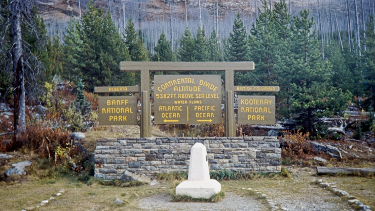
Zweiter Teil meiner transkontinentalen Reise von Vancouver nach Toronto im September und Oktober 1992. Mit dem Auto über den Trans-Canada Highway und den Icefields Parkway in die Nationalparks der kanadischen Rocky Mountains: Kootenay, Banff, Yoho und Jasper.
Bei den Fotos handelt es sich um digitalisierte und farblich restaurierte Diapositive.
Trans-Canada Highway, Columbia River und Kootenay Nationalpark
Aus dem Okanagan Valley kommend führte die Fahrt auf dem Trans-Canada Highway vorbei am “last spike” der transkontinentalen Eisenbahn über Revelstoke und Golden durch das Tal des Columbia Rivers in den Kootenay Nationapark.
[lightbox_gallery columns=”3″ size=”” hover_zoom=”yes”]
[image src=”https://thomas-ott.net/home/wp-content/uploads/2018/12/gly_BCRockies92-1.jpg” alt=””]
[image src=”https://thomas-ott.net/home/wp-content/uploads/2018/12/gly_BCRockies92-2.jpg” alt=””]
[image src=”https://thomas-ott.net/home/wp-content/uploads/2018/12/gly_BCRockies92-3.jpg” alt=””]
[image src=”https://thomas-ott.net/home/wp-content/uploads/2018/12/gly_BCRockies92-3b.jpg” alt=””]
[image src=”https://thomas-ott.net/home/wp-content/uploads/2018/12/gly_BCRockies92-4.jpg” alt=””]
[image src=”https://thomas-ott.net/home/wp-content/uploads/2018/12/gly_BCRockies92-5.jpg” alt=””]
[image src=”https://thomas-ott.net/home/wp-content/uploads/2018/12/gly_BCRockies92-6.jpg” alt=””]
[image src=”https://thomas-ott.net/home/wp-content/uploads/2018/12/gly_BCRockies92-8.jpg” alt=””]
[image src=”https://thomas-ott.net/home/wp-content/uploads/2018/12/gly_BCRockies92-9.jpg” alt=””]
[image src=”https://thomas-ott.net/home/wp-content/uploads/2018/12/gly_BCRockies92-10.jpg” alt=””]
[image src=”https://thomas-ott.net/home/wp-content/uploads/2018/12/gly_BCRockies92-11.jpg” alt=””]
[image src=”https://thomas-ott.net/home/wp-content/uploads/2018/12/gly_BCRockies92-12.jpg” alt=””]
[image src=”https://thomas-ott.net/home/wp-content/uploads/2018/12/gly_BCRockies92-13.jpg” alt=””]
[image src=”https://thomas-ott.net/home/wp-content/uploads/2018/12/gly_BCRockies92-14.jpg” alt=””]
[image src=”https://thomas-ott.net/home/wp-content/uploads/2018/12/gly_BCRockies92-15.jpg” alt=””]
[image src=”https://thomas-ott.net/home/wp-content/uploads/2018/12/gly_BCRockies92-16.jpg” alt=””]
[image src=”https://thomas-ott.net/home/wp-content/uploads/2018/12/gly_BCRockies92-17.jpg” alt=””]
[image src=”https://thomas-ott.net/home/wp-content/uploads/2018/12/gly_BCRockies92-18.jpg” alt=””]
[image src=”https://thomas-ott.net/home/wp-content/uploads/2018/12/gly_BCRockies92-19.jpg” alt=””]
[image src=”https://thomas-ott.net/home/wp-content/uploads/2018/12/gly_BCRockies92-20.jpg” alt=””]
[image src=”https://thomas-ott.net/home/wp-content/uploads/2018/12/gly_BCRockies92-21.jpg” alt=””]
[/lightbox_gallery]
Canmore, Banff, Lake Louise und Icefields Parkway
Nach einem Abstecher nach Calgary führte die Fahrt zurück in die Rocky Mountains nach Banff und Lake Louise und von dort weiter nach Norden. Der Icefields Parkway ist ein 230 Kilometer langes Teilstück des Highway 93. Der Parkway gilt als eine der schönsten Fernstraßen der Welt und führt durch die Berglandschaft der kanadischen Rocky Mountains zwischen Lake Louise und Jasper.
[image src=”https://thomas-ott.net/home/wp-content/uploads/2018/12/gly_CanRockies92-2.jpg” alt=””]
[image src=”https://thomas-ott.net/home/wp-content/uploads/2018/12/gly_CanRockies92-3.jpg” alt=””]
[image src=”https://thomas-ott.net/home/wp-content/uploads/2018/12/gly_CanRockies92-4.jpg” alt=””]
[image src=”https://thomas-ott.net/home/wp-content/uploads/2018/12/gly_CanRockies92-5.jpg” alt=””]
[image src=”https://thomas-ott.net/home/wp-content/uploads/2018/12/gly_CanRockies92-6.jpg” alt=””]
[image src=”https://thomas-ott.net/home/wp-content/uploads/2018/12/gly_CanRockies92-7.jpg” alt=””]
[image src=”https://thomas-ott.net/home/wp-content/uploads/2018/12/gly_CanRockies92-8.jpg” alt=””]
[image src=”https://thomas-ott.net/home/wp-content/uploads/2018/12/gly_CanRockies92-9.jpg” alt=””]
[image src=”https://thomas-ott.net/home/wp-content/uploads/2018/12/gly_CanRockies92-10.jpg” alt=””]
[image src=”https://thomas-ott.net/home/wp-content/uploads/2018/12/gly_CanRockies92-11.jpg” alt=””]
[image src=”https://thomas-ott.net/home/wp-content/uploads/2018/12/gly_CanRockies92-12.jpg” alt=””]
[image src=”https://thomas-ott.net/home/wp-content/uploads/2018/12/gly_CanRockies92-13.jpg” alt=””]
[image src=”https://thomas-ott.net/home/wp-content/uploads/2018/12/gly_CanRockies92-14.jpg” alt=””]
[image src=”https://thomas-ott.net/home/wp-content/uploads/2018/12/gly_CanRockies92-15.jpg” alt=””]
[image src=”https://thomas-ott.net/home/wp-content/uploads/2018/12/gly_CanRockies92-16.jpg” alt=””]
[image src=”https://thomas-ott.net/home/wp-content/uploads/2018/12/gly_CanRockies92-17.jpg” alt=””]
[image src=”https://thomas-ott.net/home/wp-content/uploads/2018/12/gly_CanRockies92-18.jpg” alt=””]
[image src=”https://thomas-ott.net/home/wp-content/uploads/2018/12/gly_CanRockies92-19.jpg” alt=””]
[image src=”https://thomas-ott.net/home/wp-content/uploads/2018/12/gly_CanRockies92-20.jpg” alt=””]
[image src=”https://thomas-ott.net/home/wp-content/uploads/2018/12/gly_CanRockies92-21.jpg” alt=””]
[image src=”https://thomas-ott.net/home/wp-content/uploads/2018/12/gly_CanRockies92-22.jpg” alt=””]
[image src=”https://thomas-ott.net/home/wp-content/uploads/2018/12/gly_CanRockies92-23.jpg” alt=””]
[image src=”https://thomas-ott.net/home/wp-content/uploads/2018/12/gly_CanRockies92-24.jpg” alt=””]
[image src=”https://thomas-ott.net/home/wp-content/uploads/2018/12/gly_CanRockies92-25.jpg” alt=””]
[image src=”https://thomas-ott.net/home/wp-content/uploads/2018/12/gly_CanRockies92-26.jpg” alt=””]
[image src=”https://thomas-ott.net/home/wp-content/uploads/2018/12/gly_CanRockies92-27.jpg” alt=””]
[image src=”https://thomas-ott.net/home/wp-content/uploads/2018/12/gly_CanRockies92-28.jpg” alt=””]
[image src=”https://thomas-ott.net/home/wp-content/uploads/2018/12/gly_CanRockies92-29.jpg” alt=””]
[image src=”https://thomas-ott.net/home/wp-content/uploads/2018/12/gly_CanRockies92-30.jpg” alt=””]
[image src=”https://thomas-ott.net/home/wp-content/uploads/2018/12/gly_CanRockies92-31.jpg” alt=””]
[image src=”https://thomas-ott.net/home/wp-content/uploads/2018/12/gly_CanRockies92-32.jpg” alt=””]
[image src=”https://thomas-ott.net/home/wp-content/uploads/2018/12/gly_CanRockies92-33.jpg” alt=””]
Columbia Icefield
Das Columbia Icefield ist eine der größten Ansammlungen von Eis südlich des Polarkreises. Seine Fläche beträgt 325 km², die Dicke 100 bis 365 m und die jährliche Schneefallmenge bis zu sieben Meter. Das Eisfeld ist das Nährgebiet von acht großen Gletschern, darunter der Athabasca-, der Castleguard-, der Columbia-, der Dome-, der Stutfield- und der Saskatchewan-Gletscher.
Der Athabasca-Gletscher fließt vom Eisfeld Richtung Nordost zum Icefields Parkway. Er wird zur einen Seite flankiert durch den 3550 m hohen Snow Dome sowie den 3450 m hohen Mount Andromeda. Durch die klimatische Erwärmung hat sich der Gletscher in den letzten 125 Jahren um 1,5 km zurückgezogen und mehr als die Hälfte seines Volumens verloren. Aufgrund seiner Nähe zum Icefields Parkway ist er einer der meistbesuchten Gletscher in Nordamerika. Im Sommer werden geführte Touren mit speziellen Bussen (den Snowcoaches) auf den Athabasca-Gletscher angeboten.
[image src=”https://thomas-ott.net/home/wp-content/uploads/2018/12/gly_CanRockies92-34.jpg” alt=””]
[image src=”https://thomas-ott.net/home/wp-content/uploads/2018/12/gly_CanRockies92-35.jpg” alt=””]
[image src=”https://thomas-ott.net/home/wp-content/uploads/2018/12/gly_CanRockies92-36.jpg” alt=””]
[image src=”https://thomas-ott.net/home/wp-content/uploads/2018/12/gly_CanRockies92-37.jpg” alt=””]
[image src=”https://thomas-ott.net/home/wp-content/uploads/2018/12/gly_CanRockies92-38.jpg” alt=””]
[image src=”https://thomas-ott.net/home/wp-content/uploads/2018/12/gly_CanRockies92-39.jpg” alt=””]
[image src=”https://thomas-ott.net/home/wp-content/uploads/2018/12/gly_CanRockies92-40.jpg” alt=””]
[image src=”https://thomas-ott.net/home/wp-content/uploads/2018/12/gly_CanRockies92-41.jpg” alt=””]
[image src=”https://thomas-ott.net/home/wp-content/uploads/2018/12/gly_CanRockies92-42.jpg” alt=””]
[image src=”https://thomas-ott.net/home/wp-content/uploads/2018/12/gly_CanRockies92-43.jpg” alt=””]
[image src=”https://thomas-ott.net/home/wp-content/uploads/2018/12/gly_CanRockies92-44.jpg” alt=””]
[image src=”https://thomas-ott.net/home/wp-content/uploads/2018/12/gly_CanRockies92-45.jpg” alt=””]
[image src=”https://thomas-ott.net/home/wp-content/uploads/2018/12/gly_CanRockies92-46.jpg” alt=””]
[image src=”https://thomas-ott.net/home/wp-content/uploads/2018/12/gly_CanRockies92-47.jpg” alt=””]
[image src=”https://thomas-ott.net/home/wp-content/uploads/2018/12/gly_CanRockies92-48.jpg” alt=””]
Mount Edith Cavell
Der Mount Edith Cavell im Jasper Nationalpark wurde 1916 nach einer englischen Krankenschwester benannt, die alliierten Soldaten zur Flucht aus Belgien verholfen hatte und darauf hin von einem deutschen Kriegsgericht zum Tode verurteilt und hingerichtet wurde. Von den Cavell Meadows auf der südlichen Talseite hat man einen traumhaften Blick auf den Angel Gletscher auf der Nordseite des Mount Edith Cavell. Der Name wurde im 19. Jahrhundert aus seiner Form abgeleitet, die an einen Engel mit ausgebreiteten Flügeln erinnert. Wie viele Eisfelder auf der Erde ist der Angel Gletscher stark von der globalen Erwärmung betroffen und wird in naher Zukunft seine besondere Form verlieren und möglicherweise ganz verschwinden. Unterhalb des Angel Gletschers befindet sich ein Gletschersee und die Reste des Cavell Gletschers an dem sich nahezu die komplette glaziale Serie studieren lässt. Auch hier ist ein dramatischer Rückgang der Eismenge zu beobachten.
[image src=”https://thomas-ott.net/home/wp-content/uploads/2018/12/gly_CanRockies92-49.jpg” alt=””]
[image src=”https://thomas-ott.net/home/wp-content/uploads/2018/12/gly_CanRockies92-50.jpg” alt=””]
[image src=”https://thomas-ott.net/home/wp-content/uploads/2018/12/gly_CanRockies92-51.jpg” alt=””]
[image src=”https://thomas-ott.net/home/wp-content/uploads/2018/12/gly_CanRockies92-52.jpg” alt=””]
[image src=”https://thomas-ott.net/home/wp-content/uploads/2018/12/gly_CanRockies92-53.jpg” alt=””]
[image src=”https://thomas-ott.net/home/wp-content/uploads/2018/12/gly_CanRockies92-54.jpg” alt=””]
[image src=”https://thomas-ott.net/home/wp-content/uploads/2018/12/gly_CanRockies92-55.jpg” alt=””]
[image src=”https://thomas-ott.net/home/wp-content/uploads/2018/12/gly_CanRockies92-56.jpg” alt=””]
[image src=”https://thomas-ott.net/home/wp-content/uploads/2018/12/gly_CanRockies92-57b.jpg” alt=””]
[image src=”https://thomas-ott.net/home/wp-content/uploads/2018/12/gly_CanRockies92-58.jpg” alt=””]
[image src=”https://thomas-ott.net/home/wp-content/uploads/2018/12/gly_CanRockies92-59.jpg” alt=””]
[image src=”https://thomas-ott.net/home/wp-content/uploads/2018/12/gly_CanRockies92-60.jpg” alt=””]
[image src=”https://thomas-ott.net/home/wp-content/uploads/2018/12/gly_CanRockies92-61.jpg” alt=””]
[image src=”https://thomas-ott.net/home/wp-content/uploads/2018/12/gly_CanRockies92-62.jpg” alt=””]
[image src=”https://thomas-ott.net/home/wp-content/uploads/2018/12/gly_CanRockies92-63.jpg” alt=””]
[image src=”https://thomas-ott.net/home/wp-content/uploads/2018/12/gly_CanRockies92-64.jpg” alt=””]
[image src=”https://thomas-ott.net/home/wp-content/uploads/2018/12/gly_CanRockies92-65.jpg” alt=””]
[image src=”https://thomas-ott.net/home/wp-content/uploads/2018/12/gly_CanRockies92-66.jpg” alt=””]
Jasper
Die 1813 gegründete Stadt Jasper diente ursprünglich als Stützpunkt der Northwest und später der Hudson’s Bay Company. Heute ist sie ein wichtiger Verkehrsknoten und Ausgangspunkt für den Tourismus im gleichnamigen Nationalpark. Meine Route führte mich von Jasper auf dem Yellowhead Highway entlang des Athabasca River bis nach Edmonton.
[image src=”https://thomas-ott.net/home/wp-content/uploads/2018/12/gly_CanRockies92-67.jpg” alt=””]
[image src=”https://thomas-ott.net/home/wp-content/uploads/2018/12/gly_CanRockies92-68.jpg” alt=””]
[image src=”https://thomas-ott.net/home/wp-content/uploads/2018/12/gly_CanRockies92-69.jpg” alt=””]
[image src=”https://thomas-ott.net/home/wp-content/uploads/2018/12/gly_CanRockies92-70.jpg” alt=””]
[image src=”https://thomas-ott.net/home/wp-content/uploads/2018/12/gly_CanRockies92-71.jpg” alt=””]
[image src=”https://thomas-ott.net/home/wp-content/uploads/2018/12/gly_CanRockies92-72.jpg” alt=””]
[image src=”https://thomas-ott.net/home/wp-content/uploads/2018/12/gly_CanRockies92-73.jpg” alt=””]
[image src=”https://thomas-ott.net/home/wp-content/uploads/2018/12/gly_CanRockies92-74.jpg” alt=””]
[/lightbox_gallery]