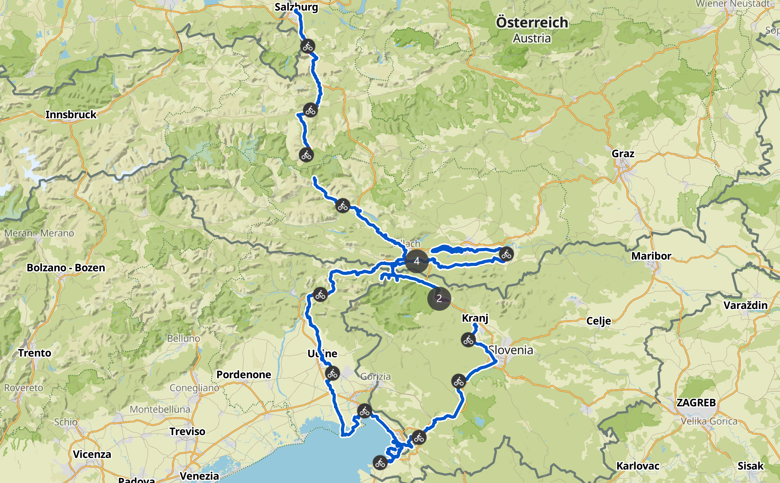
Nach der Alpenüberquerung 2022, bei der wir es aus Zeitgründen nicht bis ans Mittelmeer geschafft haben, sind wir in diesem Jahr die klassische Route von Salzburg nach Grado gefahren. Der Rückweg führte uns über Triest und durch das wunderschöne Slowenien nach Klagenfurt. Insgesamt haben wir ca. 950 Kilometer auf dem Fahrrad zurückgelegt und 7200 Höhenmeter überwunden.
01 (Weinheim -) Salzburg – Werfen
Distanz: 48,7 km
Höhenmeter: +380 / –270
Fahrzeit: 03:19 h
+++
Komoot: https://www.komoot.de/tour/1265455497
Strava: https://www.strava.com/activities/9667388816
[lightbox_gallery columns=”6″ size=”” hover_zoom=”yes”]
[image src=”https://thomas-ott.net/home/wp-content/uploads/2024/02/gly_alpeadriaxt_01_-1.jpg” alt=””]
[image src=”https://thomas-ott.net/home/wp-content/uploads/2024/02/gly_alpeadriaxt_01_-2.jpg” alt=””]
[image src=”https://thomas-ott.net/home/wp-content/uploads/2024/02/gly_alpeadriaxt_01_-3.jpg” alt=””]
[image src=”https://thomas-ott.net/home/wp-content/uploads/2024/02/gly_alpeadriaxt_01_-4.jpg” alt=””]
[image src=”https://thomas-ott.net/home/wp-content/uploads/2024/02/gly_alpeadriaxt_01_-5.jpg” alt=””]
[image src=”https://thomas-ott.net/home/wp-content/uploads/2024/02/gly_alpeadriaxt_01_-6.jpg” alt=””]
[image src=”https://thomas-ott.net/home/wp-content/uploads/2024/02/gly_alpeadriaxt_01_-7.jpg” alt=””]
[image src=”https://thomas-ott.net/home/wp-content/uploads/2024/02/gly_alpeadriaxt_01_-8.jpg” alt=””][/lightbox_gallery]
[divider style=”single” align=”center” color=”grey” opacity=”1″ width=”” pull=”” padding_top=”10px” padding_bottom=”20px”]
02 Werfen – Bad Gastein
Distanz: 61,5 km
Höhenmeter: +800 / –330
Fahrzeit: 4:49 h
+++
Komoot: https://www.komoot.de/tour/1267049761
Strava: https://www.strava.com/activities/9673637061
[lightbox_gallery columns=”6″ size=”” hover_zoom=”yes”]
[image src=”https://thomas-ott.net/home/wp-content/uploads/2024/02/gly_alpeadriaxt_02_-1.jpg” alt=””]
[image src=”https://thomas-ott.net/home/wp-content/uploads/2024/02/gly_alpeadriaxt_02_-2.jpg” alt=””]
[image src=”https://thomas-ott.net/home/wp-content/uploads/2024/02/gly_alpeadriaxt_02_-3.jpg” alt=””]
[image src=”https://thomas-ott.net/home/wp-content/uploads/2024/02/gly_alpeadriaxt_02_-4.jpg” alt=””]
[image src=”https://thomas-ott.net/home/wp-content/uploads/2024/02/gly_alpeadriaxt_02_-5.jpg” alt=””]
[image src=”https://thomas-ott.net/home/wp-content/uploads/2024/02/gly_alpeadriaxt_02_-6.jpg” alt=””]
[/lightbox_gallery]
[divider style=”single” align=”center” color=”grey” opacity=”1″ width=”” pull=”” padding_top=”10px” padding_bottom=”20px”]
03 Bad Gastein
+++
[lightbox_gallery columns=”6″ size=”” hover_zoom=”yes”]
[image src=”https://thomas-ott.net/home/wp-content/uploads/2024/02/gly_alpeadriaxt_03_-1.jpg” alt=””]
[image src=”https://thomas-ott.net/home/wp-content/uploads/2024/02/gly_alpeadriaxt_03_-2.jpg” alt=””]
[image src=”https://thomas-ott.net/home/wp-content/uploads/2024/02/gly_alpeadriaxt_03_-3.jpg” alt=””]
[/lightbox_gallery]
[divider style=”single” align=”center” color=”grey” opacity=”1″ width=”” pull=”” padding_top=”10px” padding_bottom=”20px”]
04 Bad Gastein – Böckstein | Tauernschleuse | Mallnitz – Paternion
Distanz: 70,2 km
Höhenmeter: +490 / –1040
Fahrzeit: 04:31 h
+++
Komoot: https://www.komoot.de/tour/1269433306 / https://www.komoot.de/tour/1270810286
Strava: https://www.strava.com/activities/9683027564 / https://www.strava.com/activities/9686928779
[lightbox_gallery columns=”6″ size=”” hover_zoom=”yes”]
[image src=”https://thomas-ott.net/home/wp-content/uploads/2024/02/gly_alpeadriaxt_04_-1.jpg” alt=””]
[image src=”https://thomas-ott.net/home/wp-content/uploads/2024/02/gly_alpeadriaxt_04_-2.jpg” alt=””]
[image src=”https://thomas-ott.net/home/wp-content/uploads/2024/02/gly_alpeadriaxt_04_-3.jpg” alt=””]
[image src=”https://thomas-ott.net/home/wp-content/uploads/2024/02/gly_alpeadriaxt_04_-4.jpg” alt=””]
[image src=”https://thomas-ott.net/home/wp-content/uploads/2024/02/gly_alpeadriaxt_04_-5.jpg” alt=””]
[image src=”https://thomas-ott.net/home/wp-content/uploads/2024/02/gly_alpeadriaxt_04_-6.jpg” alt=””]
[image src=”https://thomas-ott.net/home/wp-content/uploads/2024/02/gly_alpeadriaxt_04_-7.jpg” alt=””]
[image src=”https://thomas-ott.net/home/wp-content/uploads/2024/02/gly_alpeadriaxt_04_-8.jpg” alt=””]
[image src=”https://thomas-ott.net/home/wp-content/uploads/2024/02/gly_alpeadriaxt_04_-9.jpg” alt=””][/lightbox_gallery]
[divider style=”single” align=”center” color=”grey” opacity=”1″ width=”” pull=”” padding_top=”10px” padding_bottom=”20px”]
05 Paternion – Tarvisio
Distanz: 59,5 km
Höhenmeter: +490 / –250
Fahrzeit: 04:12 h
+++
Komoot: https://www.komoot.de/tour/1272079691
Strava: https://www.strava.com/activities/9691986654
[lightbox_gallery columns=”6″ size=”” hover_zoom=”yes”]
[image src=”https://thomas-ott.net/home/wp-content/uploads/2024/02/gly_alpeadriaxt_05_-1.jpg” alt=””]
[image src=”https://thomas-ott.net/home/wp-content/uploads/2024/02/gly_alpeadriaxt_05_-2.jpg” alt=””]
[image src=”https://thomas-ott.net/home/wp-content/uploads/2024/02/gly_alpeadriaxt_05_-3.jpg” alt=””]
[image src=”https://thomas-ott.net/home/wp-content/uploads/2024/02/gly_alpeadriaxt_05_-4.jpg” alt=””]
[image src=”https://thomas-ott.net/home/wp-content/uploads/2024/02/gly_alpeadriaxt_05_-5.jpg” alt=””]
[image src=”https://thomas-ott.net/home/wp-content/uploads/2024/02/gly_alpeadriaxt_05_-6.jpg” alt=””]
[image src=”https://thomas-ott.net/home/wp-content/uploads/2024/02/gly_alpeadriaxt_05_-7.jpg” alt=””]
[/lightbox_gallery]
[divider style=”single” align=”center” color=”grey” opacity=”1″ width=”” pull=”” padding_top=”10px” padding_bottom=”20px”]
06 Tarvisio – Artegna
Distanz: 78,6 km
Höhenmeter: +330 / –830
Fahrzeit: 05:04 h
+++
Komoot: https://www.komoot.de/tour/1273741842
Strava: https://www.strava.com/activities/9699212983
[lightbox_gallery columns=”6″ size=”” hover_zoom=”yes”]
[image src=”https://thomas-ott.net/home/wp-content/uploads/2024/02/gly_alpeadriaxt_06_-1.jpg” alt=””]
[image src=”https://thomas-ott.net/home/wp-content/uploads/2024/02/gly_alpeadriaxt_06_-15.jpg” alt=””]
[image src=”https://thomas-ott.net/home/wp-content/uploads/2024/02/gly_alpeadriaxt_06_-16.jpg” alt=””]
[image src=”https://thomas-ott.net/home/wp-content/uploads/2024/02/gly_alpeadriaxt_06_-17.jpg” alt=””]
[image src=”https://thomas-ott.net/home/wp-content/uploads/2024/02/gly_alpeadriaxt_06_-18.jpg” alt=””]
[image src=”https://thomas-ott.net/home/wp-content/uploads/2024/02/gly_alpeadriaxt_06_-19.jpg” alt=””]
[image src=”https://thomas-ott.net/home/wp-content/uploads/2024/02/gly_alpeadriaxt_06_-20.jpg” alt=””]
[image src=”https://thomas-ott.net/home/wp-content/uploads/2024/02/gly_alpeadriaxt_06_-21.jpg” alt=””]
[image src=”https://thomas-ott.net/home/wp-content/uploads/2024/02/gly_alpeadriaxt_06_-22.jpg” alt=””]
[image src=”https://thomas-ott.net/home/wp-content/uploads/2024/02/gly_alpeadriaxt_06_-23.jpg” alt=””]
[image src=”https://thomas-ott.net/home/wp-content/uploads/2024/02/gly_alpeadriaxt_06_-24.jpg” alt=””]
[image src=”https://thomas-ott.net/home/wp-content/uploads/2024/02/gly_alpeadriaxt_06_-25.jpg” alt=””][/lightbox_gallery]
[divider style=”single” align=”center” color=”grey” opacity=”1″ width=”” pull=”” padding_top=”10px” padding_bottom=”20px”]
07 Artegna – Grado
Distanz: 89,3 km
Höhenmeter: +290 / -250
Fahrzeit: 05:47 h
+++
Komoot: https://www.komoot.de/tour/1275349370
Strava: https://www.strava.com/activities/9706345365
[lightbox_gallery columns=”6″ size=”” hover_zoom=”yes”]
[image src=”https://thomas-ott.net/home/wp-content/uploads/2024/02/gly_alpeadriaxt_07_-1.jpg” alt=””]
[image src=”https://thomas-ott.net/home/wp-content/uploads/2024/02/gly_alpeadriaxt_07_-2.jpg” alt=””]
[image src=”https://thomas-ott.net/home/wp-content/uploads/2024/02/gly_alpeadriaxt_07_-3.jpg” alt=””]
[image src=”https://thomas-ott.net/home/wp-content/uploads/2024/02/gly_alpeadriaxt_07_-4.jpg” alt=””]
[image src=”https://thomas-ott.net/home/wp-content/uploads/2024/02/gly_alpeadriaxt_07_-5.jpg” alt=””]
[image src=”https://thomas-ott.net/home/wp-content/uploads/2024/02/gly_alpeadriaxt_07_-6.jpg” alt=””]
[image src=”https://thomas-ott.net/home/wp-content/uploads/2024/02/gly_alpeadriaxt_07_-7.jpg” alt=””]
[image src=”https://thomas-ott.net/home/wp-content/uploads/2024/02/gly_alpeadriaxt_07_-8.jpg” alt=””]
[image src=”https://thomas-ott.net/home/wp-content/uploads/2024/02/gly_alpeadriaxt_07_-9.jpg” alt=””]
[image src=”https://thomas-ott.net/home/wp-content/uploads/2024/02/gly_alpeadriaxt_07_-11.jpg” alt=””]
[image src=”https://thomas-ott.net/home/wp-content/uploads/2024/02/gly_alpeadriaxt_07_-10.jpg” alt=””][/lightbox_gallery]
[divider style=”single” align=”center” color=”grey” opacity=”1″ width=”” pull=”” padding_top=”10px” padding_bottom=”20px”]
08 Grado – Trieste
Distanz: 60,4 km
Höhenmeter: +100 / -90
Fahrzeit: 04:13 h
+++
Komoot: https://www.komoot.de/tour/1276794127
Strava: https://www.strava.com/activities/9706345365
[lightbox_gallery columns=”6″ size=”” hover_zoom=”yes”]
[image src=”https://thomas-ott.net/home/wp-content/uploads/2024/02/gly_alpeadriaxt_08_-1.jpg” alt=””]
[image src=”https://thomas-ott.net/home/wp-content/uploads/2024/02/gly_alpeadriaxt_08_-2.jpg” alt=””]
[image src=”https://thomas-ott.net/home/wp-content/uploads/2024/02/gly_alpeadriaxt_08_-3.jpg” alt=””]
[image src=”https://thomas-ott.net/home/wp-content/uploads/2024/02/gly_alpeadriaxt_08_-4.jpg” alt=””]
[image src=”https://thomas-ott.net/home/wp-content/uploads/2024/02/gly_alpeadriaxt_08_-5.jpg” alt=””]
[image src=”https://thomas-ott.net/home/wp-content/uploads/2024/02/gly_alpeadriaxt_08_-6.jpg” alt=””]
[image src=”https://thomas-ott.net/home/wp-content/uploads/2024/02/gly_alpeadriaxt_08_-7.jpg” alt=””]
[image src=”https://thomas-ott.net/home/wp-content/uploads/2024/02/gly_alpeadriaxt_08_-8.jpg” alt=””]
[/lightbox_gallery]
[divider style=”single” align=”center” color=”grey” opacity=”1″ width=”” pull=”” padding_top=”10px” padding_bottom=”20px”]
09 (Trieste -) Muggia – Izola – Trieste
Distanz: 57,7 km
Höhenmeter: +320 / -320
Fahrzeit: 04:05 h
+++
Komoot: https://www.komoot.de/tour/1278001892
Strava: https://www.strava.com/activities/9718597015
[lightbox_gallery columns=”6″ size=”” hover_zoom=”yes”]
[image src=”https://thomas-ott.net/home/wp-content/uploads/2024/02/gly_alpeadriaxt_09_-1.jpg” alt=””]
[image src=”https://thomas-ott.net/home/wp-content/uploads/2024/02/gly_alpeadriaxt_09_-2.jpg” alt=””]
[image src=”https://thomas-ott.net/home/wp-content/uploads/2024/02/gly_alpeadriaxt_09_-3.jpg” alt=””]
[image src=”https://thomas-ott.net/home/wp-content/uploads/2024/02/gly_alpeadriaxt_09_-4.jpg” alt=””]
[image src=”https://thomas-ott.net/home/wp-content/uploads/2024/02/gly_alpeadriaxt_09_-5.jpg” alt=””]
[image src=”https://thomas-ott.net/home/wp-content/uploads/2024/02/gly_alpeadriaxt_09_-6.jpg” alt=””]
[image src=”https://thomas-ott.net/home/wp-content/uploads/2024/02/gly_alpeadriaxt_09_-7.jpg” alt=””]
[image src=”https://thomas-ott.net/home/wp-content/uploads/2024/02/gly_alpeadriaxt_09_-8.jpg” alt=””]
[/lightbox_gallery]
[divider style=”single” align=”center” color=”grey” opacity=”1″ width=”” pull=”” padding_top=”10px” padding_bottom=”20px”]
10 Trieste – Postojna
Distanz: 63,3 km
Höhenmeter: +970 / –430
Fahrzeit: 05:16 h
Schon bei der Planung der heutigen Etappe war klar, dass eine große Herausforderung auf uns warten würde. Es galt von Meereshöhe in Triest hinauf in den slowenischen Karst zu gelangen. Nach einem schweren Unfall im August 2016 fährt leider die historische Zahnradbahn (mit Fahrradtransport) nicht mehr. Da von Trieste Centrale nach Ljubljana nur zwei Regionalzüge am Tag verkehren und wir nicht in Erfahrung bringen konnten, ob wir die Fahrräder im Vormittagszug garantiert mitnehmen können, blieb nur die Alternative übrig, selbst hinauf zu fahren. Den sanftesten Anstieg ermöglicht eine alte Bahntrasse, die Pista Ciclabile Giordano Cottur. Während der untere Teil asphaltiert ist, wird der obere Teil zur Herausforderung für Mensch und Material. Der grobe Schotter ist für normale Fahrradreifen kaum und mit schwerem Gepäck praktisch nicht fahrbar. Dafür weiß ich jetzt, wofür Gravelbikes gut sind. Entschädigt wird man mit einer grandiosen Landschaft, die das Karl-May-Verfilmungs-konditionierte-Boomer-Herz höher schlagen lässt.
Oben in Slowenien angekommen befindet sich gleich das parkähnlich angelegte Gestüt Lipica, wo u.a. die Pferde für die Wiener Hofreitschule gezüchtet und ausgebildet werden. Nachdem die grenznahen Tankstellen und Casinos passiert sind, lässt auch der Autoverkehr nach bzw. verlagert sich auf die parallel verlaufende Autobahn. So bleiben Zeit und Muße, den Formenschatz der Karstlandschaft zu beobachten und sich dankbar an die Mühen des Grundstudiums zu erinnern. Schließlich stammen sämtliche geomorphologischen Karst-Fachbegriffe von Ortsbezeichnungen dieser Gegend.
Nach der Mittagspause macht uns die Hitze zusehends zu schaffen. Für einen ca. 5 km langen Anstieg mit mittlerer Steigung brauchen wir fast 1,5 Stunden, da wir uns von Schattenplatz zu Schattenplatz kämpfen. Zum Glück haben auch die kleineren Orte noch Lebensmittelmärkte, denn mein Wasserverbrauch auf 10 km ist höher als der Dieselverbrauch meines Autos auf 100 km.
Am späten Nachmittag und nach fast 1000 Höhenmetern erreichen wir Postojna, wo morgen früh die zweitgrößte Tropfsteinhöhle der Welt auf uns wartet (https://de.wikipedia.org/wiki/H%C3%B6hlen_von_Postojna).
Komoot: https://www.komoot.de/tour/1279500004
Strava: https://www.strava.com/activities/9724870072
[lightbox_gallery columns=”6″ size=”” hover_zoom=”yes”]
[image src=”https://thomas-ott.net/home/wp-content/uploads/2024/02/gly_alpeadriaxt_10_-1.jpg” alt=””]
[image src=”https://thomas-ott.net/home/wp-content/uploads/2024/02/gly_alpeadriaxt_10_-2.jpg” alt=””]
[image src=”https://thomas-ott.net/home/wp-content/uploads/2024/02/gly_alpeadriaxt_10_-3.jpg” alt=””]
[image src=”https://thomas-ott.net/home/wp-content/uploads/2024/02/gly_alpeadriaxt_10_-4.jpg” alt=””]
[image src=”https://thomas-ott.net/home/wp-content/uploads/2024/02/gly_alpeadriaxt_10_-5.jpg” alt=””]
[image src=”https://thomas-ott.net/home/wp-content/uploads/2024/02/gly_alpeadriaxt_10_-6.jpg” alt=””]
[image src=”https://thomas-ott.net/home/wp-content/uploads/2024/02/gly_alpeadriaxt_10_-7.jpg” alt=””]
[/lightbox_gallery]
[divider style=”single” align=”center” color=”grey” opacity=”1″ width=”” pull=”” padding_top=”10px” padding_bottom=”20px”]
11 Postojna – Ljubljana
Distanz: 55,1 km
Höhenmeter: +440 / –680
Fahrzeit: 05:00 h
+++
Komoot: https://www.komoot.de/tour/1281110071 (Aufzeichnung unvollständig)
Strava: https://www.strava.com/activities/9731538714 (Aufzeichnung unvollständig)
[lightbox_gallery columns=”6″ size=”” hover_zoom=”yes”]
[image src=”https://thomas-ott.net/home/wp-content/uploads/2024/02/gly_alpeadriaxt_11_-1.jpg” alt=””]
[image src=”https://thomas-ott.net/home/wp-content/uploads/2024/02/gly_alpeadriaxt_11_-2.jpg” alt=””]
[image src=”https://thomas-ott.net/home/wp-content/uploads/2024/02/gly_alpeadriaxt_11_-3.jpg” alt=””]
[image src=”https://thomas-ott.net/home/wp-content/uploads/2024/02/gly_alpeadriaxt_11_-4.jpg” alt=””]
[image src=”https://thomas-ott.net/home/wp-content/uploads/2024/02/gly_alpeadriaxt_11_-5.jpg” alt=””]
[image src=”https://thomas-ott.net/home/wp-content/uploads/2024/02/gly_alpeadriaxt_11_-6.jpg” alt=””]
[image src=”https://thomas-ott.net/home/wp-content/uploads/2024/02/gly_alpeadriaxt_11_-7.jpg” alt=””]
[image src=”https://thomas-ott.net/home/wp-content/uploads/2024/02/gly_alpeadriaxt_11_-8.jpg” alt=””]
[image src=”https://thomas-ott.net/home/wp-content/uploads/2024/02/gly_alpeadriaxt_11_-9.jpg” alt=””]
[image src=”https://thomas-ott.net/home/wp-content/uploads/2024/02/gly_alpeadriaxt_11_-10.jpg” alt=””]
[image src=”https://thomas-ott.net/home/wp-content/uploads/2024/02/gly_alpeadriaxt_11_-11.jpg” alt=””]
[image src=”https://thomas-ott.net/home/wp-content/uploads/2024/02/gly_alpeadriaxt_11_-12.jpg” alt=””]
[image src=”https://thomas-ott.net/home/wp-content/uploads/2024/02/gly_alpeadriaxt_11_-13.jpg” alt=””]
[image src=”https://thomas-ott.net/home/wp-content/uploads/2024/02/gly_alpeadriaxt_11_-14.jpg” alt=””]
[image src=”https://thomas-ott.net/home/wp-content/uploads/2024/02/gly_alpeadriaxt_11_-15.jpg” alt=””]
[image src=”https://thomas-ott.net/home/wp-content/uploads/2024/02/gly_alpeadriaxt_11_-16.jpg” alt=””]
[image src=”https://thomas-ott.net/home/wp-content/uploads/2024/02/gly_alpeadriaxt_11_-17.jpg” alt=””]
[image src=”https://thomas-ott.net/home/wp-content/uploads/2024/02/gly_alpeadriaxt_11_-18.jpg” alt=””]
[image src=”https://thomas-ott.net/home/wp-content/uploads/2024/02/gly_alpeadriaxt_11_-19.jpg” alt=””]
[image src=”https://thomas-ott.net/home/wp-content/uploads/2024/02/gly_alpeadriaxt_11_-20.jpg” alt=””]
[image src=”https://thomas-ott.net/home/wp-content/uploads/2024/02/gly_alpeadriaxt_11_-21.jpg” alt=””]
[image src=”https://thomas-ott.net/home/wp-content/uploads/2024/02/gly_alpeadriaxt_11_-22.jpg” alt=””]
[image src=”https://thomas-ott.net/home/wp-content/uploads/2024/02/gly_alpeadriaxt_11_-23.jpg” alt=””]
[image src=”https://thomas-ott.net/home/wp-content/uploads/2024/02/gly_alpeadriaxt_11_-24.jpg” alt=””]
[/lightbox_gallery]
[divider style=”single” align=”center” color=”grey” opacity=”1″ width=”” pull=”” padding_top=”10px” padding_bottom=”20px”]
12 Ljubljana – Kranj | Lesce – Bled – Zgornje Gorje
Distanz: 52,3 km
Höhenmeter: +410 / –300
Fahrzeit: 03:56 h
+++
Komoot: https://www.komoot.com/de-de/tour/1281937030 / https://www.komoot.com/de-de/tour/1282220541
Strava: https://www.strava.com/activities/9735639292 / https://www.strava.com/activities/9736980787
[lightbox_gallery columns=”6″ size=”” hover_zoom=”yes”]
[image src=”https://thomas-ott.net/home/wp-content/uploads/2024/02/gly_alpeadriaxt_12_-1.jpg” alt=””]
[image src=”https://thomas-ott.net/home/wp-content/uploads/2024/02/gly_alpeadriaxt_12_-2.jpg” alt=””]
[image src=”https://thomas-ott.net/home/wp-content/uploads/2024/02/gly_alpeadriaxt_12_-3.jpg” alt=””]
[image src=”https://thomas-ott.net/home/wp-content/uploads/2024/02/gly_alpeadriaxt_12_-4.jpg” alt=””]
[image src=”https://thomas-ott.net/home/wp-content/uploads/2024/02/gly_alpeadriaxt_12_-5.jpg” alt=””]
[image src=”https://thomas-ott.net/home/wp-content/uploads/2024/02/gly_alpeadriaxt_12_-6.jpg” alt=””]
[image src=”https://thomas-ott.net/home/wp-content/uploads/2024/02/gly_alpeadriaxt_12_-7.jpg” alt=””]
[image src=”https://thomas-ott.net/home/wp-content/uploads/2024/02/gly_alpeadriaxt_12_-8.jpg” alt=””]
[image src=”https://thomas-ott.net/home/wp-content/uploads/2024/02/gly_alpeadriaxt_12_-9.jpg” alt=””]
[image src=”https://thomas-ott.net/home/wp-content/uploads/2024/02/gly_alpeadriaxt_12_-10.jpg” alt=””]
[image src=”https://thomas-ott.net/home/wp-content/uploads/2024/02/gly_alpeadriaxt_12_-11.jpg” alt=””]
[image src=”https://thomas-ott.net/home/wp-content/uploads/2024/02/gly_alpeadriaxt_12_-12.jpg” alt=””]
[/lightbox_gallery]
[divider style=”single” align=”center” color=”grey” opacity=”1″ width=”” pull=”” padding_top=”10px” padding_bottom=”20px”]
13 Bled
Distanz: 15,2 km
Höhenmeter: +240 / –240
Fahrzeit: 1:28 h
+++
Komoot: https://www.komoot.com/de-de/tour/1294404937
[lightbox_gallery columns=”6″ size=”” hover_zoom=”yes”]
[image src=”https://thomas-ott.net/home/wp-content/uploads/2024/02/gly_alpeadriaxt_13_-1.jpg” alt=””]
[image src=”https://thomas-ott.net/home/wp-content/uploads/2024/02/gly_alpeadriaxt_13_-2.jpg” alt=””]
[image src=”https://thomas-ott.net/home/wp-content/uploads/2024/02/gly_alpeadriaxt_13_-3.jpg” alt=””]
[image src=”https://thomas-ott.net/home/wp-content/uploads/2024/02/gly_alpeadriaxt_13_-4.jpg” alt=””]
[image src=”https://thomas-ott.net/home/wp-content/uploads/2024/02/gly_alpeadriaxt_13_-5.jpg” alt=””]
[image src=”https://thomas-ott.net/home/wp-content/uploads/2024/02/gly_alpeadriaxt_13_-6.jpg” alt=””]
[image src=”https://thomas-ott.net/home/wp-content/uploads/2024/02/gly_alpeadriaxt_13_-7.jpg” alt=””]
[image src=”https://thomas-ott.net/home/wp-content/uploads/2024/02/gly_alpeadriaxt_13_-8.jpg” alt=””]
[image src=”https://thomas-ott.net/home/wp-content/uploads/2024/02/gly_alpeadriaxt_13_-9.jpg” alt=””]
[/lightbox_gallery]
[divider style=”single” align=”center” color=”grey” opacity=”1″ width=”” pull=”” padding_top=”10px” padding_bottom=”20px”]
14 Zgornje Gorje – Laghi di Fusine – Podkoren
Distanz: 67,0 km
Höhenmeter: +860 / –620
Fahrzeit: 4:55 h
+++
Komoot: https://www.komoot.com/de-de/tour/1284985637
Strava: https://www.strava.com/activities/9751110808
[lightbox_gallery columns=”6″ size=”” hover_zoom=”yes”]
[image src=”https://thomas-ott.net/home/wp-content/uploads/2024/02/gly_alpeadriaxt_14_-1.jpg” alt=””]
[image src=”https://thomas-ott.net/home/wp-content/uploads/2024/02/gly_alpeadriaxt_14_-2.jpg” alt=””]
[image src=”https://thomas-ott.net/home/wp-content/uploads/2024/02/gly_alpeadriaxt_14_-3.jpg” alt=””]
[image src=”https://thomas-ott.net/home/wp-content/uploads/2024/02/gly_alpeadriaxt_14_-4.jpg” alt=””]
[image src=”https://thomas-ott.net/home/wp-content/uploads/2024/02/gly_alpeadriaxt_14_-5.jpg” alt=””]
[/lightbox_gallery]
[divider style=”single” align=”center” color=”grey” opacity=”1″ width=”” pull=”” padding_top=”10px” padding_bottom=”20px”]
15 Podkoren – Ferlach
Distanz: 62,4 km
Höhenmeter: +610 / –1020
Fahrzeit: 5:55 h
+++
Komoot: https://www.komoot.com/de-de/tour/1171064209
Strava: https://www.strava.com/activities/9756798573
[lightbox_gallery columns=”6″ size=”” hover_zoom=”yes”]
[image src=”https://thomas-ott.net/home/wp-content/uploads/2024/02/gly_alpeadriaxt_15_-1.jpg” alt=””]
[image src=”https://thomas-ott.net/home/wp-content/uploads/2024/02/gly_alpeadriaxt_15_-2.jpg” alt=””]
[image src=”https://thomas-ott.net/home/wp-content/uploads/2024/02/gly_alpeadriaxt_15_-3.jpg” alt=””]
[image src=”https://thomas-ott.net/home/wp-content/uploads/2024/02/gly_alpeadriaxt_15_-4.jpg” alt=””]
[image src=”https://thomas-ott.net/home/wp-content/uploads/2024/02/gly_alpeadriaxt_15_-5.jpg” alt=””]
[image src=”https://thomas-ott.net/home/wp-content/uploads/2024/02/gly_alpeadriaxt_15_-6.jpg” alt=””]
[/lightbox_gallery]
[divider style=”single” align=”center” color=”grey” opacity=”1″ width=”” pull=”” padding_top=”10px” padding_bottom=”20px”]
16 Ferlach – Klagenfurt
Distanz: 65,1 km
Höhenmeter: +440 / –410
Fahrzeit: 3:20 h
+++
Komoot: https://www.komoot.com/de-de/tour/1287644324
[lightbox_gallery columns=”6″ size=”” hover_zoom=”yes”]
[image src=”https://thomas-ott.net/home/wp-content/uploads/2024/02/gly_alpeadriaxt_16_-1.jpg” alt=””]
[image src=”https://thomas-ott.net/home/wp-content/uploads/2024/02/gly_alpeadriaxt_16_-2.jpg” alt=””]
[image src=”https://thomas-ott.net/home/wp-content/uploads/2024/02/gly_alpeadriaxt_16_-3.jpg” alt=””]
[image src=”https://thomas-ott.net/home/wp-content/uploads/2024/02/gly_alpeadriaxt_16_-4.jpg” alt=””]
[image src=”https://thomas-ott.net/home/wp-content/uploads/2024/02/gly_alpeadriaxt_16_-5.jpg” alt=””]
[image src=”https://thomas-ott.net/home/wp-content/uploads/2024/02/gly_alpeadriaxt_16_-6.jpg” alt=””]
[image src=”https://thomas-ott.net/home/wp-content/uploads/2024/02/gly_alpeadriaxt_16_-7.jpg” alt=””]
[image src=”https://thomas-ott.net/home/wp-content/uploads/2024/02/gly_alpeadriaxt_16_-8.jpg” alt=””]
[image src=”https://thomas-ott.net/home/wp-content/uploads/2024/02/gly_alpeadriaxt_16_-9.jpg” alt=””]
[image src=”https://thomas-ott.net/home/wp-content/uploads/2024/02/gly_alpeadriaxt_16_-10.jpg” alt=””]
[/lightbox_gallery]
[divider style=”single” align=”center” color=”grey” opacity=”1″ width=”” pull=”” padding_top=”10px” padding_bottom=”20px”]
17 Rund um den Wörthersee
Distanz: 46,8 km
Höhenmeter: +190 / –190
Fahrzeit: 03:27 h
+++
Komoot: https://www.komoot.com/de-de/tour/1289045080
Strava: https://www.strava.com/activities/9768841175
[lightbox_gallery columns=”6″ size=”” hover_zoom=”yes”]
[image src=”https://thomas-ott.net/home/wp-content/uploads/2024/02/gly_alpeadriaxt_17_-1.jpg” alt=””]
[image src=”https://thomas-ott.net/home/wp-content/uploads/2024/02/gly_alpeadriaxt_17_-2.jpg” alt=””]
[image src=”https://thomas-ott.net/home/wp-content/uploads/2024/02/gly_alpeadriaxt_17_-3.jpg” alt=””]
[image src=”https://thomas-ott.net/home/wp-content/uploads/2024/02/gly_alpeadriaxt_17_-4.jpg” alt=””]
[image src=”https://thomas-ott.net/home/wp-content/uploads/2024/02/gly_alpeadriaxt_17_-5.jpg” alt=””]
[image src=”https://thomas-ott.net/home/wp-content/uploads/2024/02/gly_alpeadriaxt_17_-6.jpg” alt=””]
[/lightbox_gallery]
[divider style=”single” align=”center” color=”grey” opacity=”1″ width=”” pull=”” padding_top=”10px” padding_bottom=”20px”]